
https://www.almayadeen.net/news/politics/تكنولوجيا-روسية-بأيد-إيرانية-ما-هي-قدرات-القمر-الصناعي-خيام
Source: al-Mayadeen net + Agencies 12 August 11:28
The Iranian Space Organization explains the duties of the “Hayyām” satellite in various fields. Iranian Communications and Technology Minister ‘Īsā Zāre‘pūr says that Russia delivered the technology of this satellite to the country.
Iranian Communications and Technology Minister ‘Īsā Zāre‘pūr commenting on the launch of the “Hayyām” satellite said on Friday that “the active diplomacy the Iranian government is following altered the agreement on buying a satellite from Russia into an agreement to deliver the technology from there”.
Zāre‘pūr added in a statement to the “IRNA” Iranian Press Agency: “We shall manufacture the Hayyām 2, 3, and 4 satellites together with Russia”. Thus pointing out that “the Hayyām satellite was designed by the Iranian Space Agency, but was produced in Russia”.
The Iranian Minister pointed out that this project was “swift”, but also “Russia opposed many pressures not to deliver this technology to Iran”.
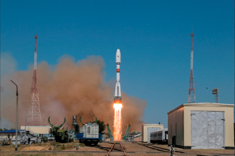
The Russian “Roscosmos” Space Agency launched an Iranian satellite on Tuesday carried by a Russian “Soyuz 2.1B” type missile from the Baykonur space base in Kazakhstan.
The agency confirmed that the missile carried the Iranian “Hayyām” satellite that was designed in Russia at the request of Tehran with 16 devices on it to be carried. The “Hayyām” satellite will take four months to be fully operational.
In the same context, the Iranian Space Agency explained that the duties of the “Hayyām” satellite will be various in the fields of agriculture, natural disaster prevention, constructional changes, mineral wealth exploration, and monitoring the water resources.
The characteristics of the “Hayyām” satellite
- The “Hayyām satellite is a distance advisory satellite with a payload of 600 kilograms and was put in orbit at a height of roughly 500 kilometers from the surface.
- This satellite contains visual support in various spectra with the precision of one meter. It was designed and built to improve the resource management of the country in various regions.
What are the capabilities of the “Hayyām” satellite?
1 – Agricultural management
The data of the “Hayyām” satellite can be used in fields like agriculture, environment control, natural disasters, urban development changes, revealing mineral wealth and water resources. Its applications in the field of agriculture include devices to study soil and plant humidity, water resources management in the agricultural fields, monitoring the range and area of agriculture in various regions, evaluating the probable yield, outlining and choosing the suitable crops, verifying the quality of the yield and identifying the complications while preventing the seasonal changes in crop production.
2 – Identifying the natural changes
Also among the duties of the “Hayyām” satellite is to prevent the seasonal changes on the land surface and to verify these. Also to prevent and verify actions contaminating the water, the air, and the soil, identify changes in the vegetation and forests, outline the dust centers, evaluate soil erosion and desertion, and prevent the soil from becoming desolate.
3 – To protect the regions hit by natural catastrophes
Among the important applications of the advisory satellites are those specifications that can help nature. The applications of the “Hayyām” satellite are connected to outlining the threats and threat assessment evaluation, but also to monitoring the affected areas and outlining the areas that can be repopulated, and then evaluating the damages.
In addition to these, the monitoring capability of the urban development counts to one of the specifications of this satellite, which monitors and studies the spread of cities, the populated areas, the changes in land usage, redraws the population maps of cities, and the countryside and monitors the unsuitable constructions.
Among the other capabilities of this Iranian satellite is the monitor and evaluate the industrial and mining areas, monitor the changes in coastal areas’ borders, and monitor the sea water and landmass surfaces, as also the water reserves held by dams.
Pic: The Iranian Space Organization explains the duties of the “Hayyām” satellite
تكنولوجيا روسية بأيدٍ إيرانية.. ما هي قدرات القمر الصناعي “خيّام”؟
المصدر: الميادين نت + وكالات 12 آب 11:28
منظّمة الفضاء الإيرانية تشرح مهام القمر الصناعي “خيّام” في مختلف المجالات، ووزير الاتصالات وتقنية المعلومات الإيراني عيسى زارع بور يقول إنّ روسيا نقلت تكنولوجيا هذا القمر إلى بلاده
قال وزير الاتصالات وتقنية المعلومات الإيراني عيسى زارع بور، اليوم الجمعة، تعليقاً على إطلاق قمر “خيّام” الصناعي، إنّ “الدبلوماسية النشطة التي تتبعها الحكومة الإيرانية غيّرت صفقة شراء قمر صناعي من روسيا إلى صفقة لنقل التكنولوجيا منها
وأضاف زارع بور في تصريح لوكالة الأنباء الإيرانية “إرنا”: “سنصنع أقمار خيّام 2 و3 و4 مع روسيا، بحسب اتفاقنا معها”، مشيراً إلى أنّ “قمر خيّام صُمّم من قبل منظمة الفضاء الإيرانية، لكنّه صُنع في روسيا
ولفت الوزير الإيراني إلى أنّ هذا المشروع كان “سرّياً”، وإلى أنّ “روسيا تعرضت لكثير من الضغوط لعدم نقل هذه التكنولوجيا إلى إيران
وأطلقت وكالة الفضاء الروسية “روسكوسموس”، الثلاثاء الماضي، قمراً صناعياً إيرانياً محمولاً بصاروخ روسي من طراز “سويوز -2.1B”، من قاعدة “بايكونور” الفضائية في كازاخستان.
وأكّدت الوكالة أنّ الصاروخ نقل إلى المدار القمر الصناعي الإيراني “خيّام”، الذي جرى تصميمه في روسيا بطلب من طهران، مع 16 مركبة صغيرة كحمولة عابرة. وسيستغرق القمر “خيام” نحو 4 أشهر حتى يعمل بكامل طاقته.
وفي السياق، شرحت منظّمة الفضاء الإيرانية مهام القمر الصناعي “خيّام” في مختلف مجالات الزراعة والكوارث الطبيعية والتغيرات العمرانية والتنقيب عن المعادن ومراقبة الموارد المائية.
مواصفات قمر “خيّام” الصناعي
– القمر “خيام” هو قمر صناعي للاستشعار عن بعد يبلغ وزنه نحو 600 كيلوغرام، وجرى وضعه في مدار على ارتفاع نحو 500 كيلومتر من سطح الأرض.
– يحتوي هذا القمر الصناعي على مستشعرات بصرية بأطياف مختلفة بدقة متر واحد، جرى تصميمها وبناؤها بهدف تحسين الإدارة المثلى لموارد الدولة في مختلف المناطق.
ما هي قدرات القمر “خيّام”؟
1- إدارة الزراعة
تُستخدم بيانات القمر الصناعي “خيام” في مجالات مثل الزراعة والبيئة والكوارث الطبيعية والتغيرات الحضرية واستكشاف المعادن والموارد المائية. تشمل تطبيقاته في مجال الزراعة دراسة رطوبة التربة والنبات، وإدارة الاستهلاك الأمثل للمياه في الحقول الزراعية، ومراقبة النطاق والمساحة المزروعة في مناطق مختلفة، وتقدير كمية المحصول قبل الحصاد، وتحديد وتعيين الأنواع المراد زراعتها، والتحقق من صحة المحصول، وتحديد الآفات ورصد التغيرات الدورية في نمو النبات.
2- تحديد المتغيرات الطبيعية
ومن المهمات الأخرى للقمر الصناعي “خيام”، رصد التغيرات الدورية في سطح الأرض والتحقيق فيها، والرصد والتحقيق في عملية حركة الملوثات في المياه والتربة والهواء، والتحقيق في التغيرات في الغطاء النباتي والغابات، وتحديد مراكز الغبار، وتقييم تدهور الأراضي والتصحر، ورصد انجراف التربة وحالة الصحاري.
3- رصد المناطق المتضررة في الكوارث الطبيعية
من التطبيقات المهمة لاستشعار الأقمار الصناعية الميزات التي تحتوي عليها والتي تساعد البيئة. ترتبط تطبيقات القمر الصناعي “خيام” في هذا المجال بنمذجة المخاطر وإعداد خرائط المخاطر، ومراقبة المناطق المتضررة، وتحديد مناطق إعادة التوطين وتقييم الأضرار.
إضافة إلى ذلك، تُعد مراقبة التغيرات العمرانية إحدى ميزات هذا القمر الصناعي، الذي يراقب ويفحص طبيعة انتشار المدن والمساحات السكانية، والتغيرات في استخدامات الأراضي، وإعداد خرائط التنمية الحضرية والريفية، ومراقبة الإنشاءات غير المصرح بها.
ومن السمات الأخرى لهذا القمر الصناعي الإيراني، المراقبة والتحقيق في انتشار الصناعات والمناجم، ومراقبة التغيرات الحدودية الساحلية، ومراقبة مساحة سطح المياه للبحيرات والأراضي الرطبة ومخزون مياه السدود